Region: Indonesia (northern Sumatra), Thailand, Malaysia, Myanmar, southern India, Nicobar and Andaman Islands, Bangladesh, Sri Lanka, Maldives, East Africa.
Date: 26 December, 2004
Event: Earthquake and tsunami
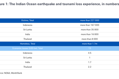
Impact: With the death toll currently almost 300,000, nine states directly affected and visitors from another 40 countries losing their lives, this stands as the greatest natural disaster ever. Aceh province in northern Sumatra was worst hit, with waves 15 m high arriving within 10 minutes of the quake travelling several kilometres inland, obliterating the capital Banda Aceh and taking close to 230,000 lives. The tsunami reached southern India and the tourist resorts of Thailand and Sri Lanka around two hours later, taking a further 70,000 or so lives. It remained powerful enough to cause more than a hundred deaths when it reached the east coast of Africa, seven hours after the quake. In northern Sumatra, the level of destruction arising from the earthquake and the tsunami is almost total, and a similar situation prevails on most of the Andaman and Nicobar Islands.
Coastal properties in Thailand, India and Sri Lanka suffered massive damage, mainly due to impact by the waves and debris and to floatation of structures from their foundations. The economic cost of the catastrophe is enormous and remains impossible to constrain accurately, with estimates ranging from $15 to 80 billion. Insured losses are also currently poorly defined, although most estimates predict less than $10 billion.
Summary: A magnitude 9.0 (Moment Magnitude Scale) earthquake occurred just before 08.00 h (local time), 160 km off the western shore of Indonesia's Aceh province in northern Sumatra. The huge size of the quake, together with its shallow depth - just 30 km below the sea floor - contributed to the formation of ocean basin wide tsunami. The earthquake was associated with the rupture of the fault boundary between the Indo-Australian and Burma plates, with the crust tearing for a distance of more than 1000 km north of the epicentre. The lateral displacement, by several metres, of the Burma plate - up and over the Indo-Australian plate - caused the ocean above to oscillate vertically and then move west and east as a series of tsunami. Formation of the tsunami may also have been augmented by submarine landslides along much of the length of the rupture in the sea bed. In deep water, wave heights were around 60 cm, at the affected coastlines, however, the tsunami built to 10 m in height, and locally perhaps as high as 15 m.
Data sources: Benfield
Indian Ocean Earthquake and Tsunami. GAPResponse reports 1, 2 and 3.
The Asian Earthquake/Tsunami Disaster: an Insurance Perspective.
Glencairn Limited
Contact: Peter Cheesman. pcheesman@glencairngroup.com
Additional sources: Earthquake Engineering Research Institute
The Indian Ocean tsunami dominated the period from July 2004 to March 2005. This catastrophe is currently estimated to have taken close to 300,000 lives in the nine countries directly affected and among visitors from another 40 states. No other natural disaster in history has affected the inhabitants of so many of the world's countries - around one-quarter in all. A massive, magnitude 9.0 (Moment Magnitude Scale) earthquake - the largest since Alaska 1964 and the fourth greatest of the last 100 years - triggered the event. It ruptured more than 1,000 km of the fault boundary that marks the contact between the Indo-Australian and Burma plates.
The quake had its epicentre 160 km west of Sumatra's northern province of Aceh, with the rupture extending northwards beneath the Nicobar and Andaman Islands. Uplift of the sea floor by several metres, augmented by the formation of submarine landslides, led to destructive tsunami propagating as far as Malaysia in the east and the African coast in the west.
The other major tectonic event of the period was the October earthquake at Niigata in Japan. While only 40 fatalities resulted, economic losses of $28 billion, make this quake the third costliest after Kobe in 1995 and Northridge CA a year earlier.
In addition, a devastating series of hurricanes, typhoons and tropical storms with associated severe wind damage and extensive flooding helped to make 2004 a record year for insured losses, of which the nine largest were the result of windstorms. Virtually all these losses occurred during the second half of 2004.
An exceptionally active year in the Atlantic Basin saw five hurricanes making landfall in the United States during August and September, with four striking the state of Florida. Economic losses arising from Atlantic hurricane activity are set at $56.3 billion, with insured losses estimated at $28.5 billion. US total insured losses due to hurricane are estimated at $20.4 billion, a 1-in-35 year event.
The typhoon season in the North West Pacific was also extremely active, with seven tropical cyclones striking mainland Japan, four of which were typhoons. Total economic losses due to typhoons Songda, Tokage and Chaba are estimated at $10.5 billion, with insured losses set at $5.05 billion.
In addition, Typhoon Rananin, the most powerful to strike eastern China in 50 years, destroyed over 40,000 homes, while Typhoons Muifa and Nanmadol took more than 1,500 lives in the Philippines.
Damaging windstorm activity in Europe was relatively subdued, although hurricane-strength winds caused damage and disruption across the northern UK, Denmark, Germany and - especially - Sweden in January, 2005. In Sweden, resulting economic losses, mainly due to lumber destruction, are estimated at between $2.8 and $4.3 billion. Unofficial estimates of insured losses are $72 million in Sweden and $176 million in Denmark. One of the five greatest blizzards ever recorded in eastern New England (US) struck on 22and 23 January 2005. The storm dumped 57 cm of snow in Boston and affected eight states. Loss estimates are currently not available.
The south Asian floods that started in June 2004 (see Disasters Report in last issue) persisted into August, claiming a total of 2,200 lives and generating economic losses on the order of $5 billion. Similarly, heavy flooding in China continued from June into September, affecting nine provinces, taking 2,000 lives and requiring the evacuation of 1.3 million people. Total economic losses are estimated at $7.8 billion. Damaging and lethal floods also occurred over the period in Bolivia, Central African Republic, China, Colombia, Costa Rica, Guyana, Panama, Romania, Slovakia, Sri Lanka and Venezuela.
Munich Re reports that around 50% of the 650 or so natural catastrophes recorded in 2004 as a whole were weather related, and these accounted for over 90% of the year's insured losses. Insured losses for 2004 were the worst ever and topped $40 billion, while economic losses, which totalled more than $130 billion, were the second worst on record.
Territory: US and Caribbean
Region: Bahamas and US (Florida)
Date: 25 August - 9 September 2004
Event: Hurricane Frances
Impact: A 3 - 5 m storm surge brought flooding to much of the Bahamas, with wind speeds of up to 165 kph causing damage to hundreds of houses and knocking out power across the islands. Grand Bahama airport was closed due to flooding and three lives were lost. In Florida, Frances brought widespread damage to coastal properties, boats and marinas, and cut power to more than 6 million people. Over 30 cm of rain caused extensive flooding and erosion.
Winds also stripped around a thousand panels from the Space Shuttle vehicle assembly building at Cape Canaveral. Total death toll for the storm is estimated at 39. Economic and insured losses are set, respectively, at $8.5 billion and $4.7 billion. Insured losses for the United States alone are estimated at $4.1 billion.
Summary: Hurricane Frances transformed from a tropical depression to a tropical storm on 25 August and achieved hurricane strength the following day while still located in the central tropical Atlantic. Frances continued to strengthen as it tracked westwards, passing 200 km north of Puerto Rico on 31 August as a category 4 storm with maximum sustained wind speeds of 224 kph. On 1 September, Frances skirted the south-eastern Bahamas and Turks and Caicos Islands, before heading north west and weakening to a category 3 storm. Weakening continued as Frances crossed the NW Bahamas on 3 and 4 September, before making landfall as a category 2 storm on 5 September at Sewall's Point, 55 km north of West Palm Beach, FL. Frances weakened to a tropical storm as it crossed the state and maintained this status as it passed into the Gulf of Mexico on 6 September and made its final landfall near St. Marks, in the Florida panhandle.
Data sources: National Hurricane Centre
www.nhc.noaa.gov
Insurance Journal
www.insurancejournal.com
Additional sources: Munich Re.
www.munichre.com/
Florida Insurance Council
www.flains.org
Territory: Japan
Region: Niigata (Honshu)
Date: 23 October 2004
Event: Earthquake
Impact: Generally effective anti-seismic building codes ensured that the toll of death and injury was small, with 40 killed and around 4,500 injured. However, more than 2,770 buildings were completely destroyed, around 10,000 partly demolished and 87,000 damaged in Niigata Prefecture.
In addition, roads and bridges were damaged and power, gas and water supplies disrupted. More than a hundred landslides and 11 reported fires contributed to the disruption. With peak ground accelerations of up to 1.7g (for Kobe 1995, pga = 0.8g) damage would have been far worse had the epicentre not been located in a largely rural area. Even so, this was the most significant earthquake to affect Japan since the 1995 Kobe quake, and estimated economic losses of $28 billion make it the third costliest earthquake after Kobe and Northridge (California, 1984). Insured losses are estimated at a lowly $450 million.
Summary: A magnitude 6.6 (Moment Magnitude Scale) earthquake struck the Japanese city of Niigata in NW Honshu on the evening of 23 October (local time). The epicentre was located 80 km south of Niigata and 195 km north of Tokyo. The shallow depth of the quake - just 13 km - ensured that, although not large, the associated shaking was severe and damage was substantial.
An aftershock sequence incorporated more than 360 events over the next 48 hours, including two in excess of Richter Magnitude 6.0. A magnitude 7.5 (Richter Magnitude) earthquake struck the city in 1964 killing 30 people and destroying 2,000 buildings, many as a result of ground liquefaction.
Data sources: Earthquake Engineering Research Institute
www.eeri.org
USGS Earthquake Hazards Program
earthquake.usgs.gov
Additional sources: University of Southern California
gees.usc.edu/GEES/RecentEQ/Japan2004/Introduction.htm
Territory: US and Caribbean
Region: Grenada, Cayman Isles, Cuba, US states Date: 2 - 24 September 2004
Event: Hurricane Ivan
Impact: Hurricane Ivan's effects were particularly widespread, with 11 countries suffering damage; Barbados, the Dominican Republic, Grenada, the Cayman Isles, Haiti, Jamaica, Trinidad and Tobago, Venezuela, St. Lucia, St. Vincent and the Grenadines, Cuba and the United States. Of these, worst hit were Granada, Jamaica, Cuba and the United States. In Grenada, nine out of 10 homes were destroyed, half the island's 110,000 population were left homeless and the economy was left in ruins. Economic losses are in excess of $100 million. In Jamaica, 5,000 homes and 340 schools were destroyed or damaged and crops sustained serious damage.
In Cuba, 650 houses and 250 schools were damaged and eight schools destroyed.
Nearly 14,000 tonnes of bananas and citrus fruits were damaged or destroyed.
Ivan brought the worst weather in 25 years to coastal Alabama, and cut power to 1.1 million homes in Alabama, Florida and Mississippi. Extensive building damage resulted from winds gusting as high as 230 kph, with a 3 m storm surge and more than 33 cm of rain leading to widespread coastal and inland flooding. In total, Ivan triggered economic losses of $20 billion, with insured losses estimated at $11.7 billion. Insured losses for the United States are set at $6 billion. The death toll is estimated at 125.
Summary: Hurricane Ivan was the most energetic Atlantic storm since reliable records began, and it also holds the record for the longest duration at category 4 intensity. This is attributed to its track through the deep tropics during conditions of very favourable sea surface temperature and low vertical wind shear. The storm was also the sixth strongest recorded in the Atlantic Basin. Ivan became a tropical storm on 3 September, reached hurricane strength two days later and developed into a major (category 3) storm the same day. The hurricane tracked westwards across the southern Windward Islands as a category 4 storm, causing major damage and loss of life, and continued on past northern Venezuela and the Netherlands Antilles.
Heading towards Jamaica on 9 September, Ivan reached category 5 status, but weakened to 4 as it skirted the south of the island. On 11 September, the storm again strengthened to category 5, before inflicting major damage to Grand Cayman. Ivan passed western Cuba and turned towards the US Gulf Coast, making landfall as a category 3 storm near Gulf Shores, Alabama.
After crossing the SE states, Ivan headed back across southern Florida and back into the Gulf of Mexico, where it made a final landfall in Louisiana as a tropical storm on 24 September.
Data sources: NOAA National Weather Service Office, Mobile/Pensacola
www.srh.noaa.gov
ReliefWeb www.reliefweb.int
Territory: US and Caribbean
Region: Cuba and US (Florida and South Carolina)
Date: 9 - 15 August, 2004
Event: Hurricane Charley
Impact: Hurricane Charley caused massive damage in Cuba's Havana Province and Havana City itself. Physical damage was widespread. 8,300 houses were destroyed and a further 40,100 damaged, with infrastructure such as hospitals, schools, water, telephone and power systems also badly disrupted. Agriculture was severely affected. When Charley came ashore at Charlotte Harbour, Florida, it became the most intense hurricane to strike the United States since Andrew in 1992. It is also the second costliest, with economic losses of $13 - 15 billion and insured losses of $7.4 billion. Total economic losses for the storm are estimated at $21.3 billion, with total insured losses set at $7.6 billion. The death toll is estimated at 32, with five in Cuba and 13 in the US.
Summary: Hurricane Charley achieved tropical storm status on 9 August and three days later it passed Grand Cayman as a hurricane. After skirting southern Jamaica, Charley crossed western Cuba as a category 3 storm on 13 August and headed north to Florida, intensifying as it travelled. US landfall occurred on the SW coast near Cayo Costa, with category 4 maximum sustained winds of 233 kph, and peak gusts of 289 kph. Charley continued to track across the state, with the eye-wall striking Port Charlotte and Punta Gorda shortly after landfall. Maximum sustained winds were still around 136 kph when the storm passed Kissimmee and Orlando on the 14th, and Charley was still a hurricane when it crossed the Atlantic coast of NE Florida near Daytona Beach. As a category 1 storm, it made further landfalls again the same day near Cape Romain and North Myrtle Beach, South Carolina, before weakening to a tropical storm and becoming extra-tropical over Virginia.
Data sources: National Hurricane Centre
www.nhc.noaa.gov
ReliefWeb www.reliefweb.int
Territory: Japan, NW Pacific islands
Region: Japan (Kyushu, Shikoku, Honshu, Hokkaido), Mariana Islands
Date: 27 August - 7 September 18 - 31 August and 12 - 20 October
Event: Typhoons
Impact: Typhoon Chaba destroyed 200 homes and damaged infrastructure in the Northern Mariana Islands. In Kyushu and Shikoku (Japan), up to 10 cm rain an hour triggered widespread flooding and landslides, inundating 13,000 homes and necessitating the evacuation of 35,000 people. Damage to power lines left a third of a million people without electricity. The death toll in Japan was 16.
Kyushu also bore the brunt of Typhoon Songda, with wind gusts in excess of 200 kph and precipitation rates as high as 10 cm/h causing further structural damage, floods and landslides. More than 46,000 homes were damaged, 1.6 million people lost power, and Mazda closed its factories in Hiroshima and Hofu. In Hokkaido, Songda caused considerable damage to the agricultural and lumber industries. More than 32 deaths were recorded and close to 1,000 injuries. Typhoon Tokage brought maximum sustained wind speeds of only around 74 kph at landfall, but gusts of up to 229 kph were recorded locally. Torrential rains triggered landslides that took close to 100 lives, while waves in excess of 9 m caused extensive coastal damage. Insured losses for Chaba, Songda and Tokage are estimated, respectively, at $950 million, $3 billion and $1.5 billion.
Summary: Typhoon Chaba struck the Northern Mariana Islands on 23 August, with winds of 287 kph and a 5.5 m storm surge causing widespread damage to buildings and power lines and heavy flooding. The hurricane tracked north west with category 5 strength before weakening and making landfall in Kagoshima prefecture, Kyushu island, as a category 2 storm on 30 August, with maximum sustained wind speeds of 160 kph. Chaba continued into western Honshu and continued to track north east off the northern coastline of the archipelago before making a second landfall near Tomakomai City in Hokkaido on 31 August. Typhoon Songda followed a similar track, crossing a sparsely populated part of the Mariana Islands before striking Kyushsu, close to Nagasaki, on 7 September as a category 2 storm and continuing on to Hokkaido. Typhoon Tokage was not particularly powerful, but its very large strong wind footprint - 800 km across - ensured that it was particularly damaging. Tokage made landfall as a tropical storm on Shikoku on 20 October and tracked north-eastwards across Honshu before heading out again into the Pacific.
Data sources: Digital Typhoon
agora.ex.nii.ac.jp/digital-typhoon/news/2004/index.html.en
Tropical Storm Risk
forecast.mssl.ucl.ac.uk
Territory: US and Caribbean
Region: Dominican Republic, Haiti, Bahamas, US (Florida)
Date: 13 - 28 September 2004
Event: Hurricane Jeanne
Impact: Torrential rains associated with Hurricane Jeanne brought massive floods and landslides to Haiti, killing more than 2,000 people and destroying more than 4,000 homes. The Dominican Republic also suffered extensive flooding and wind damage. In the Bahamas, more than 800 homes were damaged on Abaco and Grand Bahama islands, and 5,000 people affected. Total economic losses are estimated at $6.6 billion, with insured losses set at $4.5 billion, of which the United States accounted for $3.25 billion.
Summary: Tropical Storm Jeanne crossed the Leeward Islands on 14 September. Over the next three days, the storm tracked slowly westwards, bringing near hurricane force winds and torrential rains to the Virgin Islands, Puerto Rico, the Dominican Republic and Haiti over the next days. Jeanne circulated around the Bahamas while growing in strength, and on the 25th struck Abaco and Grand Bahama islands before heading west and making landfall in Florida as a category 3 hurricane within 5 km of where Hurricane Frances crossed the coastline. Jeanne weakened to a tropical storm as it crossed northern Florida and made the transition to a depression over Georgia.
Data sources: National Hurricane Centre
www.nhc.noaa.gov/ReliefWeb

